
CHARLOTTE, N.C. — Florida, Georgia and the Carolinas could see impacts in the days ahead from Tropical Storm Debby. This is the fourth storm of the 2024 Atlantic hurricane season.
Debby will continue to move NNE before slowing down through Georgia, bringing life-threatening flash flooding to Eastern Georgia and South Carolina over the next few days as North Carolina watches closely for their later in the week.


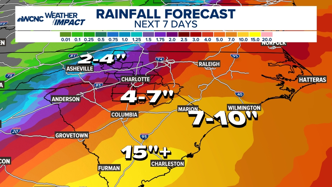
Debby will continue to weaken, but realistically, it could dump over a foot of rain over the next three days for eastern Georgia and South Carolina.
Chief Meteorologist Brad Panovich said Thursday through Saturday could be the worst for the Charlotte area when it comes to rain.
"I really want to focus on these impacts -- this will be significant flooding," Panovich said, noting not everyone will see flooding but the Piedmont in particular is likely to see a ramp-up in rain in the latter half of the week.
Ahead of severe weather moving into the area, North Carolina Governor Roy Cooper declared a State of Emergency. As Tropical Storm Debby moves through the Carolinas, it is expected to move incredibly slowly, bringing the potential for heavy rain, deadly flash flooding, wind gusts and coastal effects.
Debby is expected to move into North Carolina starting Tuesday and its impact will be felt through the end of the week.
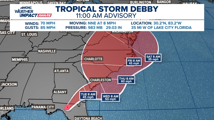
U.S. landfall
Tropical systems take the path of least resistance. With the positioning of a high-pressure system to the west combined with a cold front to the north, Debby made landfall in Steinhatchee, Florida early Monday as a Category 1 hurricane.
Debby strengthened from a tropical storm to a Category 1 hurricane as it moved through the Gulf of Mexico Sunday. By the 11 a.m. advisory on Monday, Debby had been downgraded to a tropical storm.
Eventually, it is expected to move across the state until it reaches the Georgia and Carolina coastlines. While the frontal boundary looks to block it from moving further inland, we're seeing trends suggest it could cause Debby to stall out. This is due to the combination of the front blocking northward movement, high pressure to the west too far away to move Debby, and the Bermuda high to the east too weak to turn it out to sea.
As Chief Meteorologist Brad Panovich explains, it's like being on a boat that stalls because it gets stuck behind a rock that blocks the stream's current. If any currents (in Debby's case: steering currents) are too weak or too far away, you go nowhere!

Carolina impacts
For the Carolinas, the highest impacts from Debby will be along the coast with heavy rain, dangerous beach conditions, tropical-storm-force winds and even storm surges.
This doesn't mean inland parts of the Carolinas, including the Charlotte area, won't see impacts. Increased cloud cover from the storm will begin as early as Monday night with the outermost rain bands moving in Tuesday afternoon.
However, it's the expectation that Debby will stall and bring rain for multiple days that has the WCNC Charlotte Weather Impact Team keeping you weather aware. The amount of rain we see largely depends on where the storm stalls, but we need to prepare for flooding impacts mid-late week. Some rain and cloud impacts may even linger into next weekend.

Rock Hill officials are making sure storm drains are cleared and trucks are filled up with gas ahead of the impacts. Residents in Rock Hill are encouraged by officials to have emergency kits ready as well as non-perishable food in case of power outages.
"Today and tomorrow [are] kind of the days to prepare for flooding," Panovich said. "As we get into Wednesday, Thursday, Friday -- that's when it ramps up."
Panovich said wind and tornado risks are both low, but the bigger impact to prepare for is flooding.
"Right now flooding, flooding, flooding is what should be at the top of everybody's minds," Panovich said.

Rain totals
Over the next seven days, inland communities near Charlotte will see between two and four inches of rain. Higher totals are expected along and southeast of the metro, possibly up to six inches.
The highest rainfall totals look to be along the northeastern Georgia and southern South Carolina coast, including locations like Savannah and Charleston. These areas could see over a foot of rain. From Myrtle Beach, Wilmington, to the Outer Banks, these totals will be closer to seven to ten inches.
These impacts, plus storm surge, could result in severe flooding for Carolina's coastal communities. On top of flooding, residents can expect beach erosion, dangerous surf and boating conditions, and elevated wave heights.
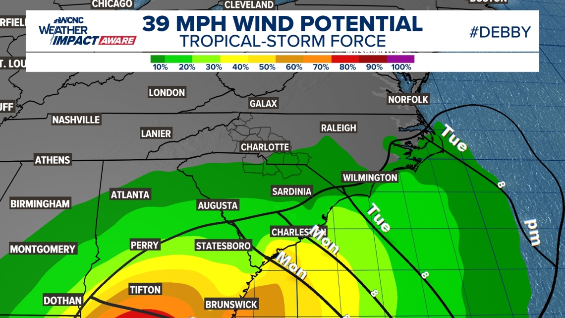
Wind speeds
Wind gusts will be slightly elevated across the Charlotte area. From Wednesday through Friday, winds could gust as high as 30 mph. Most areas will see between 20 to 25 mph.
RAISE YOUR WEATHER IQ: Brad Panovich explains the Beaufort Wind Scale
Along the coast, the highest wind gusts could peak between 35 and 45 mph. These expected winds have lowered due to Debby's expectation to stall, making it a weaker system.

What is a Potential Tropical Cyclone?
Tropical Storm Debby was previously Potential Tropical Cyclone Four. Before a storm officially forms, the National Hurricane Center can dub these tropical disturbances as "potential tropical cyclones." This classification allows NOAA to begin initiating watches and warnings to people.
NOAA began using this classification for this future storm system starting at 11 a.m. on Friday.
WCNC Charlotte’s Weather IQ YouTube channel gives detailed explainers from the WCNC Weather Impact Team meteorologists to help you learn and understand weather, climate and science. Watch previous stories where you can raise your Weather IQ in the YouTube playlist.