
MIAMI, Florida — As peak hurricane season quickly approaches on September 10th, the tropics are becoming a prime breeding ground for storms to develop. Tropical Storm Franklin and Tropical Depression #9 are the top two tropical systems to watch closely.
Both systems have the best chances of having an impact on lives and property within the next couple of days. Here's how those systems could impact the Carolinas in the coming days.
Tropical Storm Hillary made history over the weekend, becoming the first tropical storm to hit California in 84 years. The storm dumped more than half an average year's worth of rain in some areas over the weekend. The storm is now moving north along the Pacific coast.
Closer to home, here's what you need to know about the Atlantic basin as we head toward Labor Day.
Roughly 79% of tropical storms and 85% of hurricanes form during the months of August, September and October. The tropics are heating up right on time, with three tropical storms forming through the third weekend of August.
Active Named Storms
Post Tropical Storm Emily (One of the weaker Emily's):
Emily has had a history when ever it pops up but not this year.
Click to learn how infamous Emily has been in the past: Hurricane Emily: The storm that refuses to be retired
Emily is now a "post-tropical storm." This will be just a fish storm and will turn north in the Atlantic and will hit some unfavorable conditions becoming a tropical depression before fizzling out in the mid-Atlantic.
Tropical Storm Franklin (The biggest threat):
This storm is going to be a problem for flooding in the Dominican Republic. Right now, rainfall estimates bring 6-12 inches of intense rain, meaning dangerous flash flooding is going to be possible. Life-threatening flash flooding is being warned with this storm so thoughts and prayers to those who can't evacuate.
After landfall it will soak up some energy undisturbed from some warm prime Atlantic waters and become a hurricane by or before the weekend.
Tropical Storm Gert (Goodbye Gert):
Tropical Storm Gert was short lived and is now down to a tropical depression. Sustained winds dropped to 30 mph and Gert will be just a remnants storm, meaning it only will be a named storm for just over 24 hours.
Next names up - Active systems soon to be named
There are two waves being monitored that are very close to becoming a tropical depression or tropical storm.
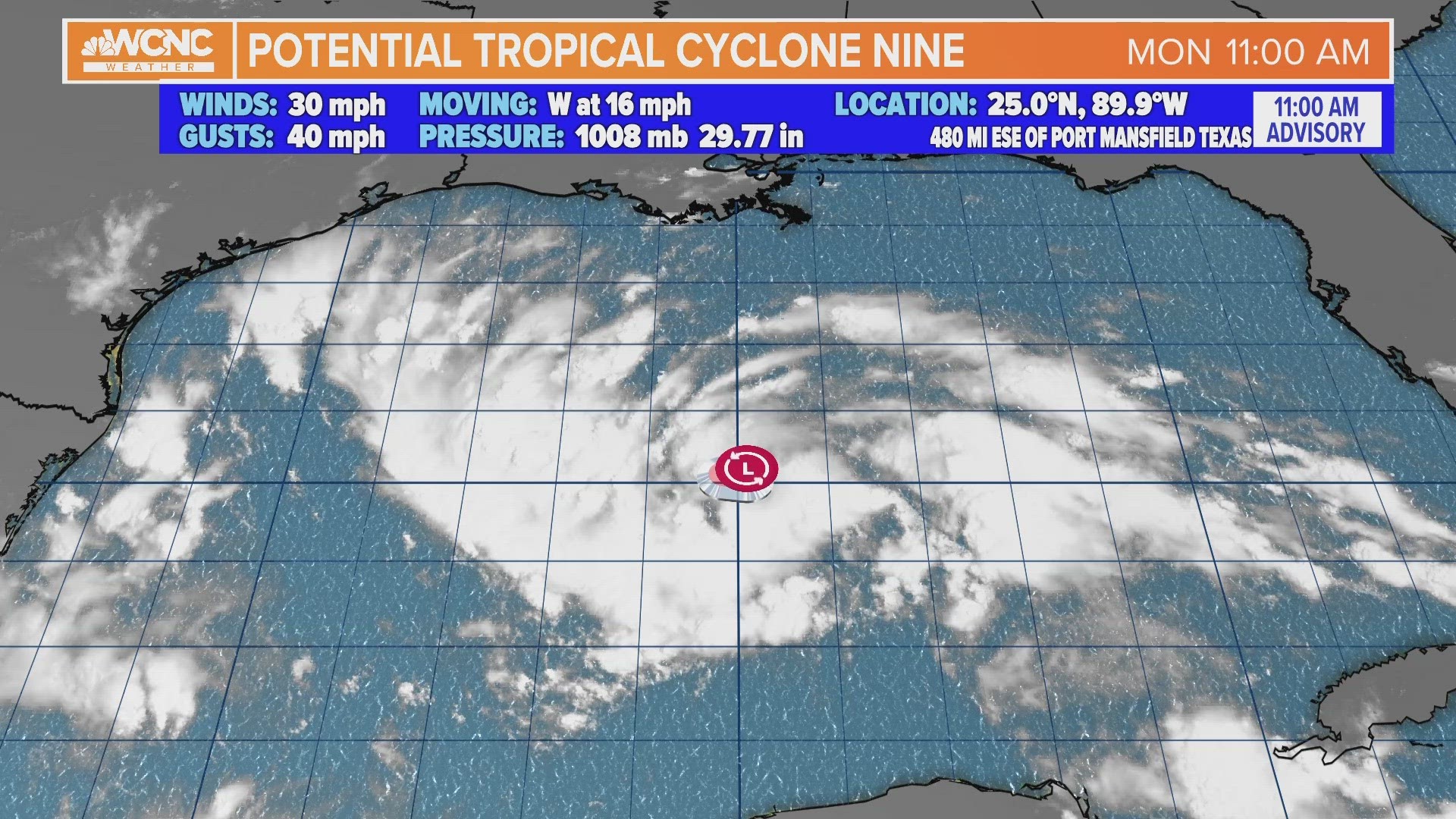
Tropical Depression #9 (Texas/Mexico landfall Tuesday):
This storm will continue to push west and make landfall in Southern Texas. Right now the intensity does not to be an issue but could be a decent rain maker for parts of Mexico and Texas. It could become a tropical storm before it makes landfall in South Texas. No storms have made landfall in the United States so far, so this is the first chance.
NOTE: Before a storm is named and is showing signs of becoming a closed circulation it will gain the name Invest followed by a number and letter. The numbers range from 90-99 and either an L (for Atlantic) or E (for Eastern Pacific). Once Invest 99L is reached, it starts back to 90L.
Invest 92L (Hurricane potential but no major threat):
This wave is well east just off the Africa coast and has the best chance to become our ninth named storm (Idalia). No other letter has been retired more than I names but it looks like if this becomes Idalia, it could become our second hurricane of the 2023 Atlantic Hurricane Season but will turn back out into the Atlantic posing no threat to land.