
CHARLOTTE, N.C. — A strong cold front will move into the Charlotte area Thursday night into Friday morning, bringing a chance for widespread rain and even the chance for a few thunderstorms. These storms could produce gusty winds capable of blowing yard furniture, bringing down small tree branches, and as a result, potentially damaging wires.
As a result of the gusty wind potential, there is a low-end severe weather risk overnight.
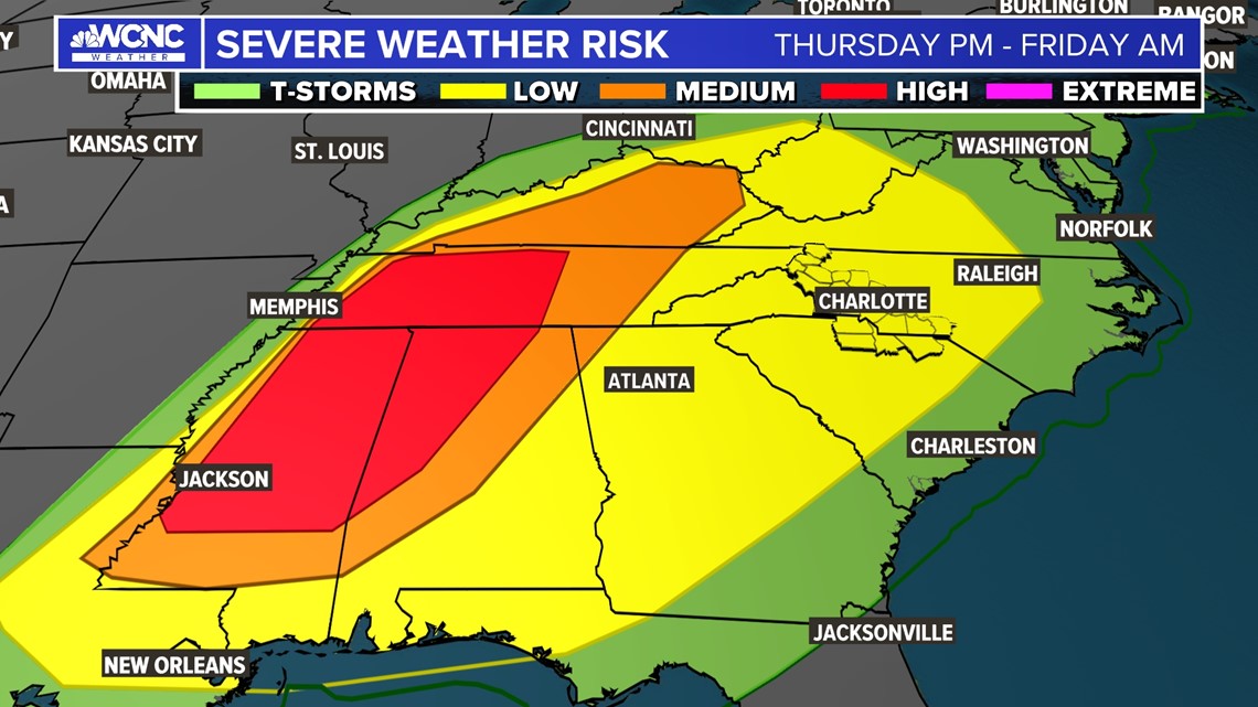
Timing and locations
Temperatures will be extremely mild and warm Thursday before the rain arrives. Temperatures will unseasonably climb into the 70s while remaining cloudy.
Additional moisture will also arrive with the warm air thus allowing for the elevated threat for some flooding and a few strong thunderstorms.
While the front will move across the entire Carolinas from west to east, the best chance of storms will initially be to the west of Interstate 77. Storms are fueled by daytime heating, and as the night progresses and the leftover heat decreases, the amount of available fuel will diminish.
Between 12 a.m. and 5 a.m. Friday, the line of remaining storms is expected to move through Charlotte.
The bigger severe threat
The worst of the severe weather will be to the west of the Carolinas.
Across areas of the Mid-South Thursday, including portions of Tennessee, Alabama, and Mississippi, the storm threat is considerably higher. Those regions will be monitoring for the threat of both damaging winds and tornadoes.
For the Carolinas, the primary threat will be gusty winds and localized flooding.

While tornadoes are not expected in the Carolinas with this storm, our Weather IQ series recently reminded us tornadoes are possible in the Carolinas during the winter.
The 'brief' cooldown
The cooldown brought on by Friday's cold front will happen gradually with temperatures falling by late afternoon. Low temperatures Saturday and Sunday will be near freezing.
By Tuesday, temperatures will be back in the 70s - with more chances for scattered storms - as spring-like weather tries to take over.
Contact Chris Mulcahy at cmulcahy@wcnc.com and follow him on Facebook, Twitter and Instagram.
Wake Up Charlotte To Go is a daily news and weather podcast you can listen to so you can start your day with the team at Wake Up Charlotte.
SUBSCRIBE: Apple Podcasts || Spotify || Stitcher || TuneIn || Google Podcasts
All of WCNC Charlotte's podcasts are free and available for both streaming and download. You can listen now on Android, iPhone, Amazon, and other internet-connected devices. Join us from North Carolina, South Carolina, or on the go anywhere.