CHARLOTTE, N.C. —
Hurricane Ida makes landfall
Officially at 11:55 AM CDT Hurricane Ida made landfall as an extremely dangerous category 4 hurricane near Port Fourchon, Louisiana. Winds were sustained at 150 mph and a minimum central pressure of 930 mb. That is an extremely strong hurricane and this will be one of worst hurricanes to ever impact the United States. We really will not know how much damage or will be done from this storm until it clears.
Location: Over Louisiana
Impacts: United States northern Gulf coast: including Louisiana, Mississippi, Alabama, and the western Florida panhandle
Katrina Comparison:
Coincidentally, Hurricane Katrina also made landfall in Louisiana on August 29th about 50 miles from where Ida made landfall. Katrina did peak to a category 5 reaching 175 mph but it made landfall at 125 mph. That is 25 mph weaker than Ida.
What's Next:
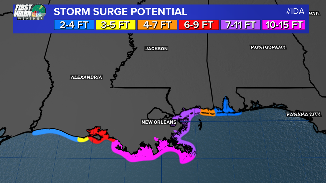
Ida will continue to move Northwest at around 10-15 mph. Storm surge will be the worst (7-15 feet) over the next 6-12 hours and some areas near landfall could see 10-15"+ of rain over the next 24 hours. Major flooding is already happening and some houses will be leveled from the intense winds at landfall. New Orleans and other communities can only pray the Levees hold.
Ida was so strong that it reversed the flow of the Mississippi River Sunday evening in Louisiana.
Tornadoes: Monday-Wednesday the severe threat expands across Ida's path. Like with what happened with Fred, multiple tornadoes can form from the outer bands of the tropical system. Even though it will quickly become a tropical depression by Monday night, the severe storms and tornadoes will become the main story along with some flash flooding.
Timeline:
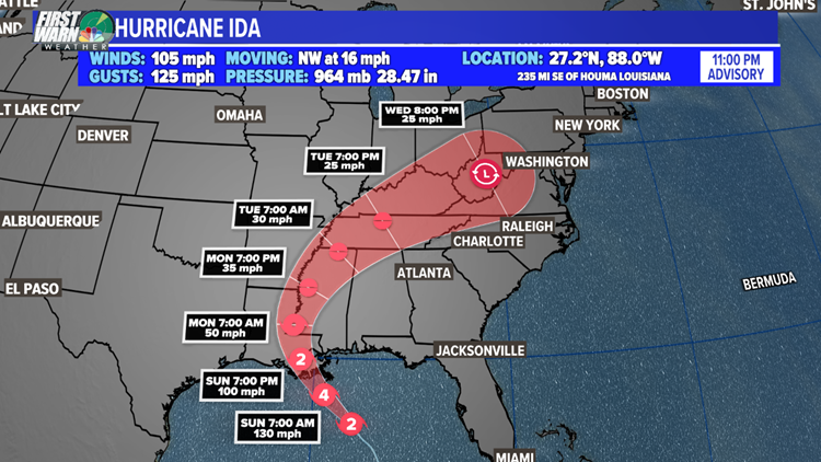
Sunday night: Ida will weaken over northern Louisiana and become a category 1 hurricane
Monday Morning: Ida will be in Western Mississippi near Jackson and wind speeds will be down to tropical storm strength
Monday Afternoon: TORNADO threat increases within Ida's outer bands
Monday Evening: Ida will move through northern Mississippi and weaken to a Tropical Depression:
Tuesday: Ida will move into Tennessee in the morning and then exit into Kentucky by the evening. Heavy rain and flooding is possible along with enhanced severe thunderstorm and tornado threats during the afternoon and evening.
What has happened so far:
On August 26th, Tropical storm Ida was born and it strengthened to a Category 1 hurricane just after 1 p.m. August 27th. Shortly after, the storm made landfall on the Isle of Youth, the second-largest Cuban island. The second landfall was near Pinar Del Rio, Cuba with sustained winds at 80 mph. It was over the island for about 3-4 hours.
Saturday through Sunday Morning: Ida went into a process called "rapid intensification" as it moved through the Gulf of Mexico. These warm waters allow for hurricanes historically to thrive and grow. Two examples are Hurricane Katrina (2005) and Hurricane Michael (2018).
- Central pressure will dropped significantly
- The eye wall formed Saturday evening
- Sustained winds increase over 50 mph in a 24 hour period
Storm Surge:


Historically, storm surge is the largest threat to life and property within a tropical cyclone. The water level rise due to Ida is expected to be the worst from Morgan City, LA to the mouth of the Mississippi River where the water levels could peak between 10 to 15 feet.
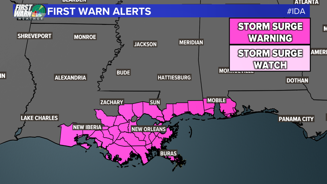
A Storm Surge Warning is in effect for east of Rockefeller Wildlife Refuge, Louisiana to the Alabama/Florida border, Vermilion Bay, Lake Borgne, Lake Pontchartrain, Lake Maurepas, and Mobile Bay.


Rainfall:
One of the worst features of a hurricane is the amount of rain it brings to an area. Louisiana is incredibly low in elevation for flooding and storm surge is magnified. The peak rain around the core is estimated to be up to 15"+. Also 3-10" of rain will spread across Mississippi.
Tropical Depression Ten
Tropical Depression Ten formed in the central Atlantic Ocean Saturday morning. The system is expected to drift northward over the next few days when it could become a tropical storm.
It's expected to stay well east of the Lesser Antilles and will be a tropical storm by mid week.
Post-Tropical Julian
This storm is done and just hung out in the mid-Atlantic.
Tropical Wave 1
Location: Over Africa
Development Chance: 80% within the next five days
This is a new area to monitor in the Atlantic Basin. A tropical wave is expected to emerge off the African coast by mid-next week. Conditions will be marginally conducive for development.
It's much too early to know what could happen with this disturbance. However, this will likely become another named storm this week. Stay tuned for updates!


