
BEECH MOUNTAIN, N.C. — Beech Mountain had active snow falling on Tuesday afternoon. If enough of the snow falls to be officially measurable, it could be one of the earliest snowfalls on record in North Carolina.
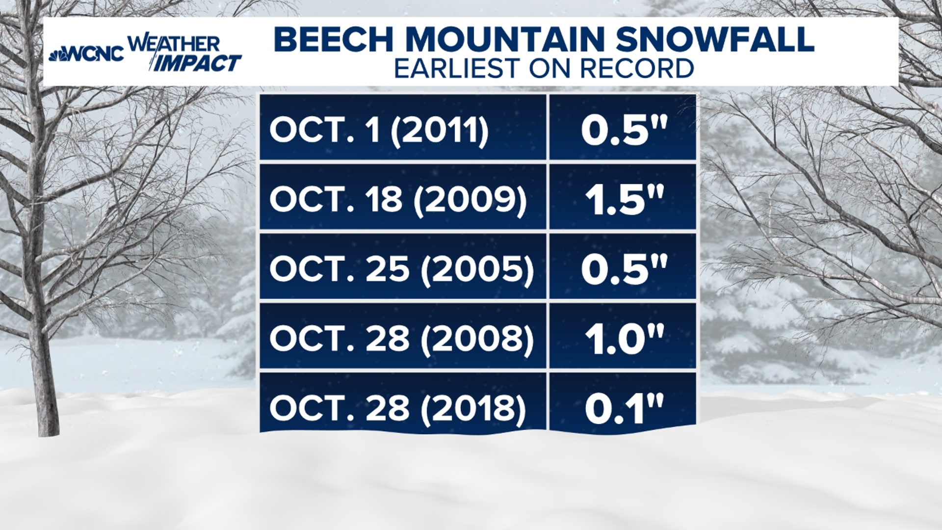
The current record is 0.5 inches that fell between the evening of September 30 and the morning of October 1 in 2011.
Tuesday's snow was enough to cause reduced visibility and a coating on grassy surfaces.
Tuesday's snow in the western North Carolina mountains is approximately one-to-two weeks earlier than normal.
WCNC Weather Impact Chief Meteorologist Brad Panovich said areas at 5,000 feet and above typically see their first snowfall in mid-October. Areas at lower elevations typically have to wait until at least late October.


Early indications is the winter in North Carolina this season could be slightly warmer and slightly drier than usual. While that could limit the chances of snow in places like Charlotte, it does not completely eliminate it.
Official North Carolina snow record
The Public Information Statement (PNS) from the National Weather Service in Greenville-Spartanburg read:
NATIONAL WEATHER SERVICE GREENVILLE-SPARTANBURG SC
207 PM EDT THU OCT 6 2011
...PUBLIC INFORMATION STATEMENT...
...EARLIEST SEASONAL MEASURABLE SNOW IN NORTH CAROLINA...
THE NWS COOPERATIVE OBSERVER ON BEECH MOUNTAIN... NORTH CAROLINA
RECORDED ONE HALF (0.5) INCH OF SNOW THAT OCCURRED BETWEEN 10 AM AND
NOON ON SATURDAY MORNING... OCTOBER 1ST... 2011. THAT IS THE
EARLIEST MEASURABLE AUTUMN SNOW ON RECORD AT A NATIONAL WEATHER
SERVICE OBSERVATION SITE IN NORTH CAROLINA.
THIS SNOWFALL REPORT WAS ENTERED ON THE OBSERVERS OBSERVATION
RECORD FOR OCTOBER 2ND BECAUSE THE SNOWFALL OCCURRED AFTER HIS DAILY
REPORTING TIME OF 7AM ON OCTOBER 1ST. COOPERATIVE OBSERVER REPORTS
INCLUDE DATA FOR THE LAST 24 HOURS...TYPICALLY FROM 7 AM THE
PREVIOUS DAY TO 7 AM THE DAY OF THE REPORT.
THE PREVIOUS EARLIEST FALL AND WINTER SEASON MEASURABLE SNOW IN
NORTH CAROLINA WAS FOUR (4.0) INCHES AT MT. MITCHELL ON THE 5TH OF
OCTOBER 1980.