
CHARLOTTE, N.C. — Every Thursday, the U.S. Drought Monitor issues a map that updates the drought status for each state. North Carolina and South Carolina, for the second week in a row, have seen drastic increases in dry to drought conditions across the state.
This means the Carolinas are officially under a flash drought.
A flash drought, according to the U.S. Drought Monitor, is "the rapid onset or intensification of drought. It is set in motion by lower-than-normal rates of precipitation, accompanied by abnormally high temperatures, winds, and radiation. Together, these changes in weather can rapidly alter the local climate."
The most recent update
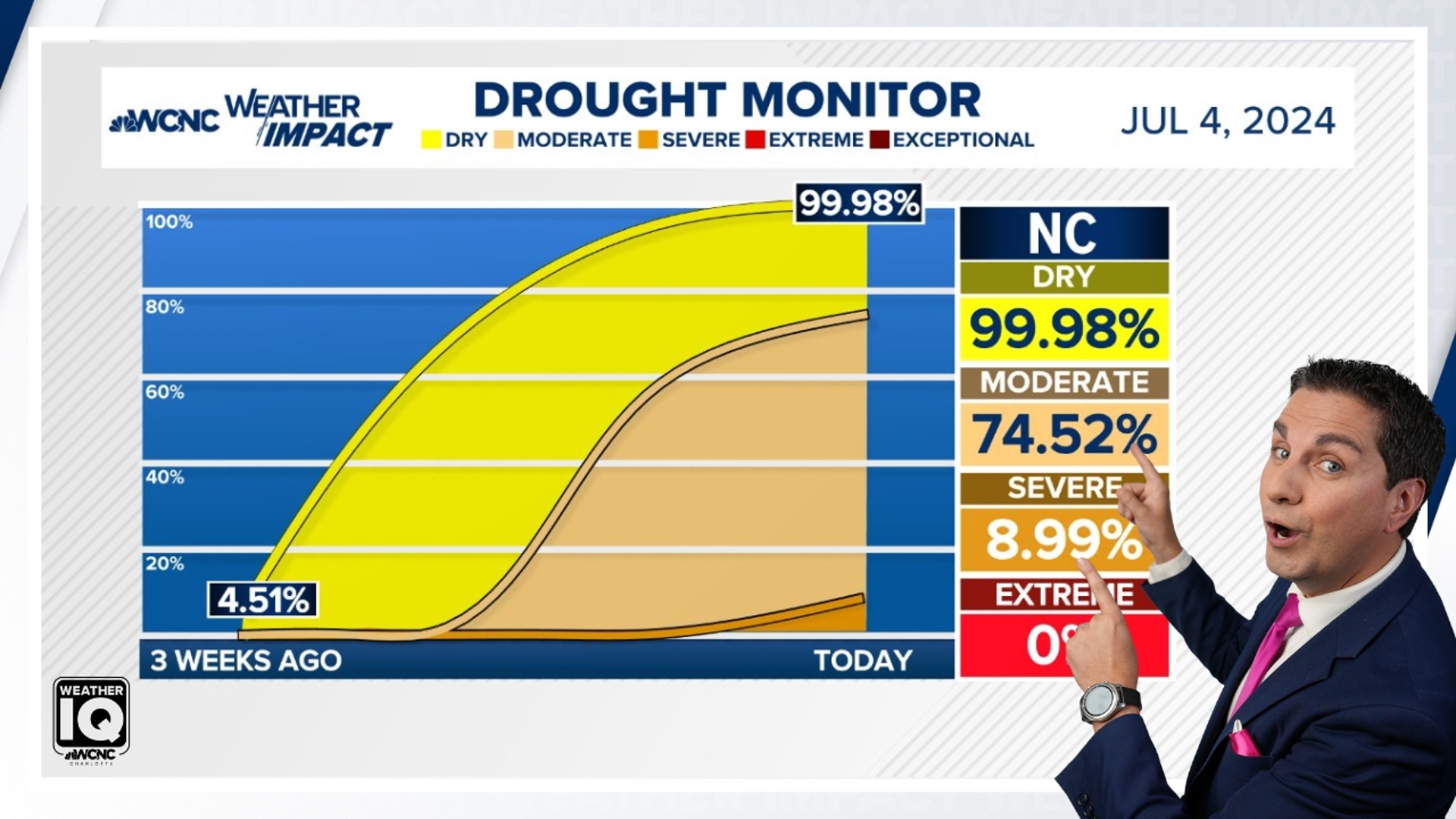
All but 0.03% of the Carolinas is now at least under a abnormally dry to as worse as a severe drought.
South Carolina technically improved by 0.01% but that is splitting hairs. However, the moderate drought increased by over 30% and now over 16% of the state us under a severe drought.
North Carolina is at is now at 99.98% abnormally dry to moderate/severe drought. The last time North Carolina was around 100% of the state was back in 2009.
This is not a good situation this time of year because:
- Evapotranspiration increased: Evaporation from the soil and by transpiration from plants.
- Most plants are at their peak water need which are sucking the soil dry.
- Hotter days in the mid to upper 90s are forecast to continue which means the need to rain is becoming dire.
Effects of Abnormally Dry status (D0)
- Lawns are brown
- Pastures are dry
- Some crop stress
- Increased irrigation needed
For the latest weather alerts, download the WCNC Charlotte mobile app and enable push notifications.
Effects of Moderate Drought status (D1)
- Crop stress increases
- Hay production is reduced
- Trees and landscape are drought stressed
- Streamflow is reduced
- Lake and reservoirs levels decline
- Voluntary water conservation begins
- Wildfire danger is higher than the seasonal normal
RELATED: Our drought status and Red Flag Warning definition (2021 Weather IQ)
What needs to happen?
We need it to rain. Plain and simple.
The WCNC Charlotte viewing area is mostly under an abnormally dry status but many parts have been upgraded to moderate drought per the most recent drought monitor map shown below.


A slow soaking rain is what is ideal. A half inch of rain over 12 hours is more beneficial than an inch over one hour.
June has only had an inch of rain and is close to 3 inches below normal. So even though the year is up overall, the recent hot and dry conditions have made that data null and void. We will need the average July rainfall plus the June deficit to get out of this drought hole (5-6 inches of rain but not all at once).
So try and conserve water, especially if you have a well, and fingers crossed those pop-up thunderstorms become more frequent as soon as possible.
Contact Chris Mulcahy at cmulcahy@wcnc.com and follow him on Facebook, X, Instagram and TikTok.