
TAMPA, Fla. — Hurricane Milton will go down in history as one of the fastest growing hurricanes on record. At 11 a.m. on Sunday, Oct. 6, Milton was a tropical storm with sustained winds of 65 mph. And now 25 hours after that, it became the 42nd Category 5 hurricane one record and the second to form this year (2024).
Hurricane Milton formed its eye-wall shortly after midnight on Oct. 7, immediately ramping up the rapid intensification. The 90 mph increase in 24 hours, is second to only Hurricane Wilma in Atlantic basin Hurricane history.
And hour later, it strengthened to a Category 5 hurricane as its maximum sustained winds increased to 160 mph (250 kph), the National Hurricane Center said.
Why did Milton grow so fast?
Besides the ideal conditions, the size of the eyewall was key. This pinhole eye wall may look small, but an eye like this has lead to some of the strongest hurricanes on record, like:
- Andrew (1992)
- Charley (2004)
- Wilma (2005)
- Maria (2017)
The pinhole eyewall
A pinhole eye is a telling sign for stronger winds and rapid intensification. The smaller the eye of a hurricane, the faster it spins and the faster it grows. If a figure skater has their arms spread out as they spin, the spin slowly, but as they pull their arms in closer to their body, they spin faster. This is the same concept known as the conservation of angular momentum (we won't expand any further than that).
Milton will weaken at some point as it goes through its 'Eye-Wall Replacement' which will make the hurricane take a step back to take a bigger step forward.
There are several factors that can weaken a hurricane:
- Dry air
- Wind Shear
- Landfall
- Cooler Waters
Water temperatures are like jet fuel in the mid 80s which is ideal for development.
Dry air
A tropical storm or hurricane is just a spinning group of thunderstorms. So when dry air or Saharan dust are filtered into a tropical disturbance or a well defined tropical cyclone, it will mess with development and strengthening.
Milton is so strong and growing so quickly, that dry air is blocked to the north and the Tropical Jet stream is protecting the hurricane from being disturbed by it.
Wind shear
This will eventually weaken Milton before landfall but is again trapped to the north and will just barely miss intervening in Milton's rapid growth. Wind shear is the change of wind speed and/or direction with height. This
There should be some high wind shear that will cut into Milton before landfall, bringing it to Category 3 or lower before landfall. This is a saving grace but it won't help reduce the storm surge.
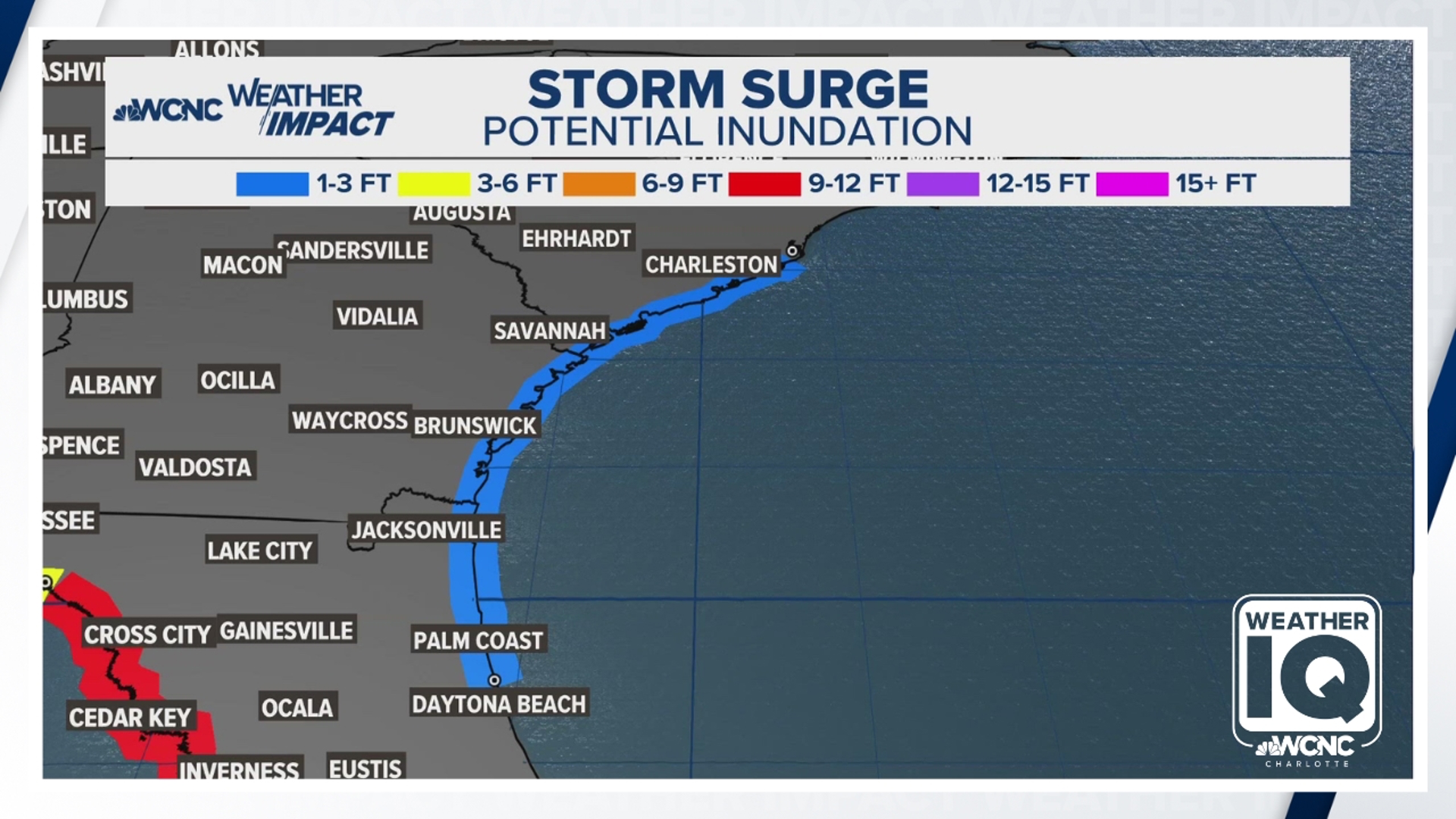
Milton will likely have a peak storm surge up to 12 feet and even though the storm will weaken, it will have already elevated so much water the storm surge values won't have time to come down before it hits Florida.
Landfall
Since the tropical jet stream grabs the storm, Milton will be in Florida for likely less than 12 hours (but the tropical storm impacts will be felt for much longer). Milton will become a tropical storm as it passes back into the Atlantic and is no threat to curve back into the Carolinas.
Milton's landfall location can be anywhere on the Florida Gulf Coast at this time and is expected to make landfall from mid evening on Wednesday to early Thursday morning.
Milton's "dirty side" will cause the worst damage to Florida. Raise your Weather IQ as to what the "dirty side" of a hurricane means.
Contact Chris Mulcahy at cmulcahy@wcnc.com and follow him on Facebook, X, Instagram and TikTok.